Geosciences
See the supervisors involved in Geosciences in the School, and the projects they'll be working on in the coming year.
Dr Agathe Lise-Pronovost
PhD Thesis Project:
Paleomagnetic records from Australian lake sediments and their incorporation into geomagnetic field models commencing in 2023
Field location: Lakes in Victoria and Queensland, Australia
Sponsor: The PhD project is supported by a scholarship within the framework of an Australian Research Council (ARC) Discovery Early Career Research Award (DECRA) Project
Supervisors:This PhD Project would be supervised by Dr Agathe Lise-Pronovost (School of Geography, Earth and Atmospheric Sciences, the University of Melbourne) with co-supervision by Assoc. Prof. David Heslop (Australian National University) and Dr Monika Korte (GFZ, Germany).
Project: The objective of this project is to construct high quality records of Earth’s magnetic field over the last 10,000 years in Australia and integrate the new data into geomagnetic field models. The study sites are lakes known to contain reliable sedimentary paleomagnetic records and located in a critically under-documented region of the globe. The integration of Australian paleomagnetic data into the next generation of geomagnetic field models for the Holocene will importantly contribute to the international effort understanding Earth’s magnetic field evolution and future impact on society.
The PhD student will be involved with lake sediment coring, core opening and sampling, paleomagnetic analyses and geomagnetic field modelling. The student will be based in Melbourne and work as part of an international team with expertise in sedimentary magnetism and geomagnetic field modelling. The candidate will play a key role in constructing high-quality centennial-scale resolution paleomagnetic records from Australian lake sediments.
Skills required: We are looking for an enthusiastic and highly motivated student to undertake a PhD project in paleomagnetism. We would encourage students with a Honours or Masters research degree or equivalent in Earth Sciences, Geophysics or equivalent, to apply. It would be advantageous to have the following skills (or a strong interest in developing them): paleomagnetism, conducting laboratory experiments, programming, or related disciplines.
Support: The applicant will receive a full stipend (living allowance) of up to $34,400 per year (increased annually). All costs of the project are covered by funds from the Project. The scholarship includes visits to ANU in Canberra for paleomagnetic analyses, a 4-week's visit to GFZ (Germany) and participation to at least one international conference.
Research Environment: The University of Melbourne is a research-intensive university and the School of Geography, Earth and Atmospheric Sciences has an active program in key areas of Earth Sciences research. You will join a lively and collegial team of post-graduate students working on related projects.
How to apply? Applications will be reviewed from the 16th of December 2022. Applicants should submit 1) a cover letter, 2) a CV, 3) academic transcripts and 4) the names and contact details of two referees via email to Dr Agathe Lise-Pronovost (agathe.lise@unimelb.edu.au).
Dr Samuel Boone, Dr Ling Chung, Prof. Andrew Gleadow, Prof. Barry Kohn, Melbourne Thermochronology Research Group
Developing AI-powered automated digital microscopy techniques for the Earth Sciences
The Melbourne Thermochronology Research Group is seeking a highly motivated MSc candidate to pursue a project in the fields of Computer Science and Earth Science at the University of Melbourne, Australia, to begin in 2023. As part of a cross-disciplinary collaboration between the MTRG, the School of Computer and Information Systems and members of the Melbourne Data Analytics Platform (MDAP), this project aims to utilise machine learning techniques to develop artificial neural networks which are capable of identifying, quantifying and characterising microscopic crystallographic features in minerals. Digital microscopy is an emerging cornerstone technology for the Earth sciences, enabling scientists to quantify the optical, morphological and compositional characteristics of geological materials and constrain their provenance, chemical, pressure and thermal histories. The implementation of machine learning techniques into digital microscopy will enable unprecedented analytical automation, helping to remove user bias and making these powerful techniques more widely available to a wider non-specialist community.
The project will focus on the digital fission track methodology, a microscopy-based geological dating technique involving the identification and measurement of radiation damage zones in crystals resulting from spontaneous fission of 238U atoms. This is a technique pioneered by researchers in the MTRG who have developed the world’s leading technology in this area (Fission Track Studios). Utilising an existing database of more than 30,000 photomicrograph stacks of fission tracks in mineral grains, the MSc candidate will develop, train and test an artificial neural network for the purposes of automatically identifying and quantifying 3D crystallographic features under the supervision of MTRG and MDAP researchers. The applicability of the resulting image analysis algorithms to other digital microscopy techniques will also be explored.
Advancing the new monazite fission track technique - a cutting-edge tool for potential investigations into ancient wildfires, paleoclimate and landscape evolution
This MSc will place the candidate at the forefront of developing the cutting-edge monazite fission track technique (MFT), an ultra-low temperature thermochronometer recently developed in the Melbourne Thermochronology Research Group. Laboratory-based experiments (Jones et al., 2021 - Geochronology) indicate that the MFT technique is sensitive to ambient temperatures of geological timescale, making it a potentially powerful new tool for investigating a wide arrray of Earth processes ranging from dating ancient bushfires, constraining past periods of climate change, and quantifying geomorphological landscape evolution.
Through a combination of laser ablation inductively coupled mass spectrometry (LA-ICP-MS), digital microscopy, borehole studies and field sampling, this project will use analytical- and natural-laboratory experiments to test potential applications of this powerful new thermochronology method.
Find an expert: Dr Samuel Boone
Find an expert: Prof. Andrew Gleadow
Find an expert: Prof. Barry Kohn
Melbourne Thermochronology Research Group
A/Prof. Stephen Gallagher
Microfossils, climate and environment
The following project combines various stratigraphic techniques with microfossil assemblage and stable isotope geochemistry (once the labs reopen) to interpret Cenozoic to recent climate and ocean change:
- The Twelve Apostles: age and environment change through the Middle Miocene Climate Optimum 15 million years ago
- Castle Cove, Cape Otway: the icehouse cometh, a window into the first Cenozoic icesheets 33 million years ago
- International Ocean Discovery Program: evidence of the waxing and waning of the British Irish Icesheet over the last 500,000 years from offshore Ireland.
Find an expert: A/Prof. Stephen Gallagher
Prof. Ralf Haese
Can we reduce atmospheric CO2 by carbon mineralisation?
Carbon mineralisation is a prospective negative emission technology to reduce atmospheric CO2. The idea is to mobilise cations (Ca, Mg, Fe) from mafic and ultramafic rocks under acidic conditions and to precipitate those ions together with carbon from atmospheric CO2. In this study, the pyroclastic (volcanic) rock scoria will be used as a cation source and elevated CO2 pressure will acidify the solution. Once the cation concentrations are high enough, the CO2 pressure will be reduced and carbonate minerals precipitate. Scoria samples from the Newer Volcanic Province will be characterised and simple flow-through experiments (see figure) carried out at various conditions. Simple geochemical modelling using commercial software will be used to explain the observations.
Find an expert: Prof. Ralf Haese
A/Prof Kevin Hill, A/Prof Sandra McLaren & Dr Eleanor Green
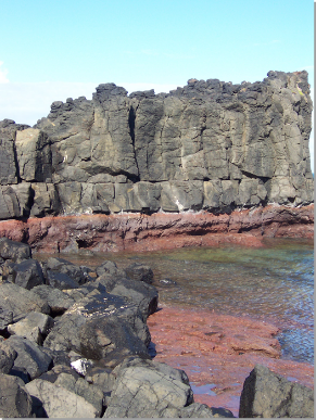
Mapping and modelling the Cambrian unconformity and Bell Point Fault Zone at Cape Liptrap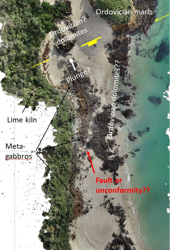
This project is field-based and will involve mapping the east coast of Cape Liptrap, ~200km SE of Melbourne. Mapping will be digital using a tablet or phone so that the data can be transferred into a work-station using the academic licence of MOVE owned by A/Prof. Sandra McLaren. The fault zone and unconformity along the east coast of Cape Liptrap was mapped by Cayley et al (2002, AJES 49 p. 225-254) suggesting a Proterozoic subduction zone beneath folded Ordovician and Devonian carbonates. New geochemical analyses (Bisits in prep) cast a different light on the underlying ophiolite and new (2022) high resolution drone images allow detailed mapping of the fault and unconformity along the coast in a zone ~2 km long. Using the drone images and Field-Move software the fault and unconformity will be mapped in detail, tying into the geochemistry project by Eleanor Green and Kevin Hill. The data will be entered into Move software to facilitate section construction and potentially a 3D model. The aims are to determine the nature and extent of the unconformity, its deformation history and relationship to the Bell Point Fault Zone.
Find an expert: A/Prof Kevin Hill
Prof. Reid Keays
Research Project on the A1 Gold Mine
The A1 Gold mine, which is one of Victoria’s premier gold (Au) mines has been producing Au intermittingly since 1861, is located in the mountains to the south of Mansfield, Victoria. Much of the A1’s Au production has come from planar quartz reefs developed in reverse faults in the diorites of the ~80 metre wide A1 dyke, which is a member of the Woods Point Dyke Swarm. Recently, a new style of Au mineralization has been discovered in the A1 mine, this being disseminated Au in a granophyric rock that is composed mainly of albite and quartz-albite granophyric intergrowths together with disseminated pyrite, which hosts the Au. The project on offer involves mapping and core logging to establish the relationship between the “normal” dioritic rocks and the granophyric rocks. Laboratory work on the disseminated Au and the granophric host rock will be done using advanced geochemical techniques such as LA-ICP-MS analysis. The aims to the project are to determine 1) the relationship between the two styles of Au mineralization, 2) the genesis of the disseminated Au (is it a product of metamorphic fluids as all the other bedrock Au deposits in Victoria or is it magmatic?) and 3) the petrogenesis of the granophyric rock.
Find an expert: Prof. Reid Keays
Dr Agathe Lise-Pronovost
Budj Bim Indigenous technology
The Budj Bim World Heritage Cultural Landscape is internationally recognised for preserving the world’s oldest aquaculture system, which provided an economic and social base for the Gunditjmara people of South-western Victoria for more than six millennia. What technologies were used by Gunditjmara people to carve canals in the volcanic landscape? Oral tradition suggests that fire was used to assist cracking, but empirical evidence is lacking.
This project will use archaeomagnetic analysis to provide evidence for ancient fire technology. With permission from the traditional owners, volcanic rock samples will be collected in and out the canals. Stepwise thermal demagnetisation will inform on the heating histories since the 40,000 years old Tyrendarra lava flow, including an evaluation of bushfire effect.
This project is part of a larger project led by Dr Martin Tomko (School of Engineering, The University of Melbourne) that aims to elucidate the engineering processes that enabled the Gunditjmara to site, plan, construct, operate and maintain this aquaculture complex, to show how it may have evolved over time, and how it responded to changing social and environmental circumstances. The student will conduct the magnetism experiments at the Australian Archaeomagnetism Laboratory at La Trobe University (Melbourne) in collaboration with Professor Andy Herries.
Find an expert: Dr Agathe Lise-Pronovost
Dr Jan-Hendrik May
Upcoming and potential projects
Hendrik (Henne) May is a geomorphologist with a focus on Quaternary landscape evolution in the Southern Hemisphere. His main interest is reconstructing the impact that climatic changes have on landscape-scale Earth surface processes utilizing field and laboratory methods as well as remote sensing and GIS. He has ongoing research projects in several parts of Australia (e.g. Flinders Ranges, lower Murray River, Top End) and cooperative projects in NW Argentina and China.
Possible HSc and MSc research projects include (but are not restricted to):
- Late quaternary human and environmental history of the Central Murray River – a GIS aided literature review (associated with DP200101875 Environmental and cultural change along the Central Murray River)
- Investigating climate and environmental controls on sedimentary dynamics along the Central Murray river (associated with DP200101875 Environmental and cultural change along the Central Murray River)
- Source-bordering dunes and their value in understanding the late Quaternary fluvial history of the lower Murray River (associated with DP200101875 Environmental and cultural change along the Central Murray River)
- Pleistocene Aeolianites along the Victorian south coast – sedimentology and paleoenvironmental significance
- Late Quaternary landscape evolution along the Werribee River, Victoria
- Testing grain sized based methods of reconstructing wind speed variations in NW Argentina over the last 1.2 Mio years
- Understanding changing sedimentary environments in a high-elevation elevation Andean landscape (NW Argentina)
Find an expert: Dr Jan-Hendrik May
A/Prof. Sandra McLaren
Tectonic and geochemical significance of granites from the Mount Isa Inlier
Granites of the Mount Isa inlier are unusually enriched in heat producing elements and also come critical rare earth elements. This project would look at the isotopic composition of some of these to try and understand their source and the processes involved in their formation and how these processes are linked to the tectonic evolution of the inlier.
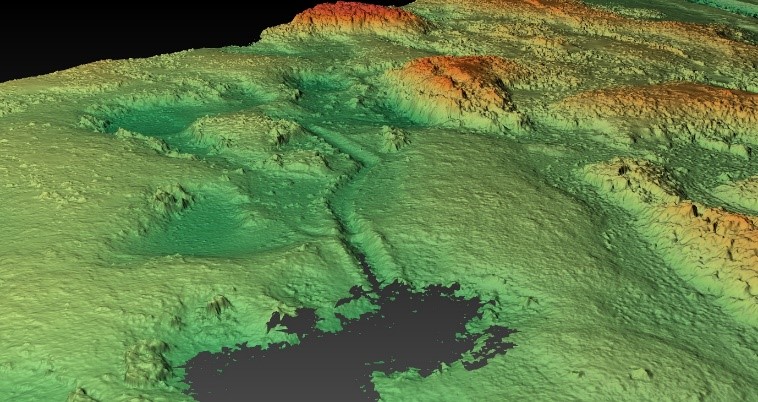
Landscape evolution and geomorphology of the PNG Highlands
The extremely remote highlands of Papua New Guinea are part of Australia's active continental margin. This project would involve looking at new generation LiDAR data as well as other remotely sensed data and connecting those datasets to the geology and landform evolution. May involve co-supervision with physical geography academics (TBA)
Thermal structure of the Australian lithosphere
Heat flow studies that may involve petrophysical measurements (thermal conductivity) geochemistry and/or involvement with other groups (Geoscience Australia or state geological surveys)
tectonics projects - in collaboration with Kevin Hill - topics to be discussed
Possibility for other projects involving structural modelling and larger scale tectonic processes - to be agreed between Sandra and any interested student
Find an expert: A/Prof. Sandra McLaren
Prof. David Phillips and Dr Hayden Dalton
Origin of volcanism in SE Australia: older volcanics (VIC) and newer volcanics (VIC, SA)
The project involves fieldwork, petrography, mineral chemistry, geochemistry and possibly 40Ar/39Ar dating.
Find an expert: Prof. David Phillips
Find an expert: Mr Hayden Dalton
Dr Amy Prendergast
Was the spread of plant and animal domestication in the Mediterranean influenced by climate change?
The domestication of plants and animals and the shift from hunter-forager to pastoral-agricultural lifeways in the Neolithic was one of the biggest changes in the history of humankind. In the Mediterranean, this began at different times and occurred in different ways across the region. This project seeks to characterise the potential influence of rapid climate change events in the Neolithic transition. It will involve generating high-resolution palaeoenvironmental records from archaeological sites across the Mediterranean using carbonate geochemistry.
Exploring how prehistoric tropical communities adapted to Late Pleistocene to Holocene environmental change in Vietnam
This project combines archaeological, geological and ecological history of the Tràng An massif World Heritage site, Ninh Binh, Vietnam. We will use geochemical records from land snail shells preserved in several archaeological sites to reconstruct local environmental conditions experienced by the region’s past inhabitants. This project will involve aspects of modern proxy validation as well as palaeoenvironmental reconstruction.
Calibration of new high-resolution sea surface temperature proxies for southeastern Australia using mollusc shell chemistry
Mollusc shells have periodic growth increments which allow the reconstruction of chronologically constrained records of palaeoenvironmental variability at unparalleled high temporal resolution. Studying the growth and chemistry of these periodic growth increments is known as sclerochronology. There are few high-resolution marine palaeoenvironmental proxies available for southeastern Australia. Mollusc shell sclerochronology holds great promise for reconstructing quantitative, sub-seasonally resolved sea surface temperature and salinity records from this region via the analysis of shells from Late Pleistocene to Holocene archaeological sites.
However, before these archives can be used for palaeoenvironmental reconstructions, it is necessary to undertake modern calibration studies to understand how geochemical variations are influenced by local environmental conditions, kinetic and vital effects. This allows the generation of quantitative and reliable proxy records of environmental change. This project will use field and lab-based sclerochronological methods on intertidal mollusc species to calibrate new high-resolution palaeoenvironmental proxies for southeastern Australia.
Using giant clam shells to reconstruct past environments and cyclone activity in the tropical Pacific
Giant clams (Tridacna spp.) are one of the major carbonate components of tropical reef systems. Their shells have annual growth increments. By analyzing the growth and chemistry of these increments it is possible to reconstruct past environmental conditions as well as short term events such as cyclones. This project will employ these techniques on modern and fossil clams to provide a palaeoenvironmental and palaeostorm reconstructions from the Late Holocene using samples from the Great Barrier Reef and Polynesia.
Understanding paleoenvironments and human interactions around a mid-Holocene shell midden in South America’s largest inundation savannah(jointly supervised with Dr Jan-Hendrik May)
Early to mid-Holocene archaeological sites are extremely rare in the Amazon basin. Anthropogenic shell middens provide valuable windows into past human-environmental interactions in the northern Bolivian inundation savannah, and hold clues on the type of existing resources, their seasonal to longer-term variability in the landscape, and their link to the natural and paleoenvironmental dynamics in a tropical riverine environment. This project addresses these questions via developing high-resolution records of paleoenvironmental change and seasonal resource use by applying microscopic, geochemical and sclerochronological techniques to freshwater apple snail shells (Pomacea spp.) from a midden in the Bolivian Amazon.
Find an expert: Dr Amy Prendergast
A/Prof. Malcolm Wallace and Dr Ashleigh Hood
Earth's history through sedimentary geology
Sedimentary rocks record almost four billion years of Earth’s environmental evolution and the evolution of life. Research in sedimentary geology can be used to identify the timing of tectonism, past climate and vegetation history, environmental change and the evolution of the oceans and atmosphere. Sediment hosted ore deposits and the diagenesis of sediments are also aspects of this research which can be related to industry projects.
Ashleigh Hood and Malcolm Wallace can supervise or co-supervise a variety of projects related to sedimentary geology in any of these areas depending on what prospective Masters and Honours students are interested in. Any project would likely be a combination of fieldwork, petrography and sedimentary geochemistry (laser/isotopes).
Some examples of active areas of research include:
- Precambrian sediments of the Flinders Ranges including those related to “Snowball Earth”.
- Neoproterozoic reefs and the evolution of reefs on the early Earth (Flinders Ranges).
- The oxygenation of the oceans and atmosphere.
- Phanerozoic iron stromatolites and link to environmental conditions (Flinders Ranges, Victoria).
- Unusual microbialites from Victorian lakes (analogue for Mars?).
- Palaeozoic marine redox and link to animal-plant evolution (Victoria, NSW, Tasmania)
- Archean carbonates and seawater conditions (Western Australia).
- Rare earth elements in paleo-oceanography
- McArthur basin, marine evolution and mineralisation (NT)
Next steps
Once you've found a researcher you'd like to work with, we encourage you to get in touch with them and talk about potential projects. Then, download and fill out the Honours, Masters and PhD supervisor form (PDF 199.1 KB) and include it in your application.