We investigate active faults and earthquake records to better understand seismic hazards in Australia's continental interior and beyond.
Australia’s dry and arid landscape preserves a unique record of faulting from the Neotectonic period. Historical earthquakes include numerous events greater than magnitude 6, substantial damage to urban centres such as the 1989 Newcastle earthquake in New South Wales, and events capable of producing significant shaking over large distances, such as the 2021 magnitude 5.9 Woods Point earthquake in Victoria.
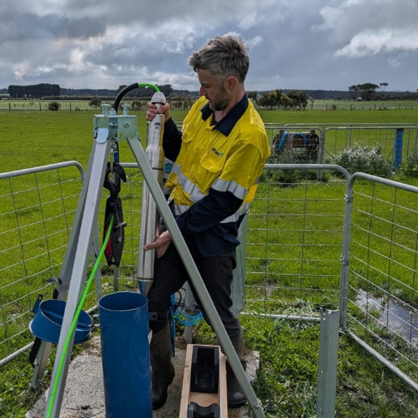
Our group investigates earthquake deformation as recorded in the geological record, as observed in the shorter-term seismological record, and works to understand the implications for large-scale tectonics, plate strength, and hazards to infrastructure and society. We engage in fieldwork and fault mapping, 3D fault modelling, employ remote sensing techniques, support short seismological network, and have participated in aftershock studies across Australia over the last decade. Our research primarily focuses on active faults in Australia but also extends to other continental regions around the globe.
If you are interested in earthquakes in intraplate settings, seismic hazard, geological and fault mapping, paleoseismology, seismological monitoring, topographic and geomorphic analysis — or if you simply have questions about earthquakes — please feel free to get in touch with us.
Funding bodies
![]()
![]()
News
Contact
Media enquiries
A/Prof Mark Quigley - mark.quigley@unimelb.edu.au
Seismic instrumentation enquiries
Dan Sandiford - dsand@unimelb.edu.au
Prospective student enquiries
A/Prof Mark Quigley - mark.quigley@unimelb.edu.au
General enquiries
A/Prof Mark Quigley - mark.quigley@unimelb.edu.au

Meet the academics and researchers in the Earthquake Research Group.
Director
A/Prof Mark Quigley
Research fellows


Graduate researchers
Ambica Sharma
Bethany Eaton
Hashim Al Musawi
James La Greca
Olivia Kulesza
Tom Savige
Trinugroho Trinugroho
Yunqi Huang
Research capabilities
Our research group focuses on understanding the nature and mechanics of seismogenic faulting and how these processes influence seismic hazards at both regional and site-specific scales. Our mission is to advance earthquake science in support of more resilient communities. To achieve this, we combine the following expertise.
Earthquake geology and paleoseismology
Earthquake geology
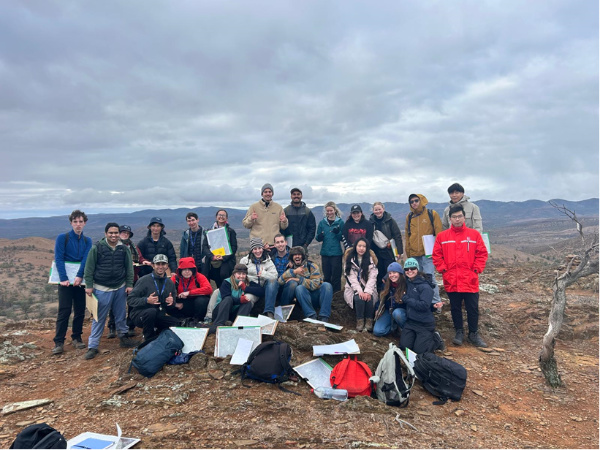
We map surface fault traces, offset geomorphic markers, and earthquake deformation features—applying both field-based and remote-sensing approaches—to characterise rupture magnitude and kinematics, fault and off-fault deformation characteristics, and to better understand earthquake rupture behaviour.

Paleoseismology
We conduct paleoseismic trench excavations, in collaboration with Geoscience Australia, to map fault geometry at shallow depths and constrain the timing of prehistoric earthquakes, in order to better understand short-term slip rates on faults.
Structural geology
We survey regions characterised by earthquake hazard, exploring seismic-related complex structural deformation features through field work and remote observation, assisting in describing and analysing the effects of seismic activity on local environments.
Geophysics
The UoM Earthquake Science Group has expertise in the use of shallow crustal geophysical methods (MASW, GPR, seismic reflection, seismic refraction) to investigate fault structure and the geophysical properties and distributions of fault proximal rocks and sediments. We also use geophysical modelling methods to simulate faulting and earthquakes in pure and applied science contexts. Our recent research in these areas includes (i) modelling of static stress changes induced by faulting, (ii) GPR analysis of Australian neotectonic fault structure, (iii) understanding geodynamic controls on fault spacing and geometry in the lithosphere.
Tectonic geomorphology (See Vermeer paper)
We apply field, remote observation and laboratory techniques to investigate the complex interplay between landscape forms and their response to active tectonic strain and fault development.
Earthquake seismology
Earthquake source characterisation
We monitor regions of anomalous historical seismicity within Australia with high-density networks, employing advanced earthquake identification and location techniques.
Aftershock analysis
We analyse the statistical properties of aftershock sequences, including the magnitude-frequency distribution, spatial-temporal distribution, aiming to understand their behaviours and relationship with the mainshock and the source fault.
Ground motion characterisation
We compute the earthquake ground motion using open-sourced codes developed by our group based on kinematic rupture modelling and wave-propagation theory to facilitate the seismic hazard assessment.
Engineering geology
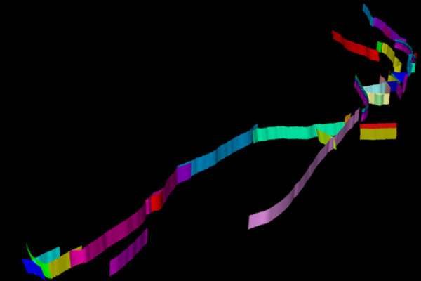
3D fault and structural modelling
We perform 3D fault and structural modelling involves integrating diverse datasets, including seismic data, magnetic and gravity data, surface faults, well and borehole data, geological outcrops and maps, earthquake data, DEM and satellite images.
Site characterisation
We use imaging techniques like Multichannel Analysis of Surface Waves (MASW) surveys, and direct measurement of rock properties to characterise near-surface site characteristics.
Site-specific geological hazard mapping
Seismic hazard assessment
PSHA
We perform probabilistic seismic hazard assessment (PSHA) for earthquake ground shaking, involving earthquake source characterisation, occurrence rate modelling, ground motion characterisation, for classic, event-based and scenario-based cases.
PFDHA
We perform probabilistic fault displacement hazard assessment (PFDHA) based on the earthquake approach using up-to-date fault displacement models from global databases.
Earthquake multi-hazard modelling
We perform other types of earthquake-related hazard assessment using computational simulation and numerical modelling approaches, including soil liquification, landslides, tsunamis and so on.
Research and industry collaborations
The UoM Earthquake Science Group collaborates widely with national, state, and regional government agencies in Australia and New Zealand. We also work closely in collaboration with industry partners in the geological, geotechnical, and engineering areas. We commonly act as independent technical expert peer-reviewers on a variety of geological and engineering topics including geological hazards, fault characterisation, seismic hazard analysis, earthquake environmental effects, and engineering geology. Our consulting and industry collaboration work includes areas of dam safety, critical infrastructure hazard analysis, national seismic hazard modelling, probabilistic fault displacement hazard analysis, and other topics.
Services
- Analysis of LiDar, SRTM, and other geospatial data for mapping, visualisation and analysis of geological, geomorphic, earthquake and climate hazards for risk management and mitigation.
- UAV drone surveys and post-processing for a high-resolution digital elevation model.
- Liquefaction and paleo-liquefaction hazard analysis.
- Paleoseismic trench investigations of faults.
- Earthquake rapid response: Temporary seismic deployment (aftershock, injection, swarms).
- Forward and inverse modelling of earthquake deformation interferogram; interpretation of coseismic InSAR imagery.
- Site-specific PSHA and PFDHA.
- Site response modelling.
- Strong ground motion and ground displacement prediction.
- 3D fault and structural modelling.
- Interpretation of 2D and 3D seismic data.
- Analysis of borehole data.
- Shallow seismic imaging (MASW).
- Earthquake relocation.
Learn more about our services
Publications
Recent featured publications
- Sethanant, I., Nissen, E., Bergman, E., Oliva, S. J., Pousse-Beltran, L., Karasözen, E., & Pananont, P. (2025). Recent earthquakes on unmapped faults highlight hidden seismic hazards within the Golden Triangle region of Laos, Thailand and Myanmar. Geophysical Journal International, 241(1), 606-627.
Featured in EarthScope June 2025 News & Features:
https://www.earthscope.org/news/golden-triangle-temblors-reveal-thickness-of-earthquake-prone-crust/
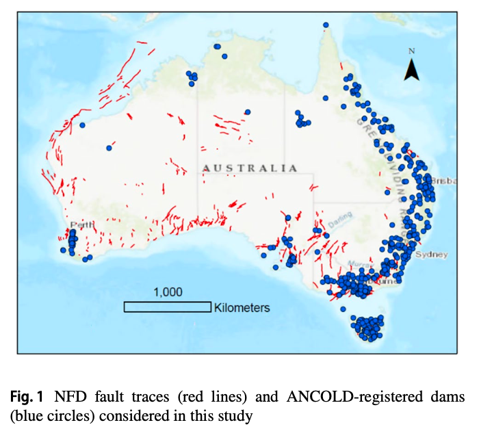
- Quigley, M., Werner, T., Tang, Y., Clark, D., Griffin, J., & Yang, H. (2025). Exposure of Australian dams to seismic hazard from proximal faults. Environment Systems and Decisions, 45(2), 24.
Other research publications by
We are available to provide technical short-course training or workshops, such as PSHA, geophysics, etc. We work with our media partners to deliver accurate and credible science information to the general public.
Educational products
Watch video
- Geology of Melbourne - Watch playlist on YouTube
- Mid-Afternoon Masterclass: Mapping the geology of Melbourne
- 3D of Melbourne workshop (video), earthquake lectures
- Earthquake Q&A with Dr. Mark Quigley (2021 Mw 5.9 Woodspoint earthquake, Victoria, Australia)

Textbook chapters
Earthquakes
by Mark Quigly and Brendan Duffy
Earthquakes and related phenomena such as landslides and tsunamis have caused more than 700,000 fatalities, millions of injuries, and more than $US 700 billion economic loss since the start of the 21st century. With a growing population and supporting infrastructure, the world’s exposure to natural disasters is inevitably increasing. Some scientists predict that more than 2.5 million earthquake fatalities will occur in the 21st century.
Outreach articles
-
Articles from A/Prof Mark Quigley on Pursuit
Associate Professor in active tectonics and geomorphology, School of Geography, Earth and Atmospheric Sciences, Faculty of Science, University of Melbourne.
-
Articles from A/Prof Mark Quigley on The Conversation
A/Prof Quigley has research interests in earthquake geology, structural geology and active tectonics, paleoclimate and tectonic geomorphic responses and landscape evolution.
-
Articles from A/Prof Mark Quigley on Geo Down Under
-
How earthquake science supports decision-making in the ancient continent
There is a widely held perception that potentially destructive earthquakes in Australia are rare.
-
Monitoring Melbourne’s Sunbury earthquake
Melbourne’s latest earthquake is the largest to occur this close to the CBD since 1932 and highlights the need for more monitoring, particularly in western Victoria.
-
Seismic ears to the ground
A high-precision seismic network is now able to detect about 400 earthquakes every year in Victoria’s Gippsland region, providing key information to protect people and infrastructure.
Subjects
- 2024-present ERTH30002 Applied Geoscience
- 2023-present GEOG30021 The Disaster Resilient City
- 2023-present GEOL20002 Investigating Earth's Structure
- 2023-present GEOL30002 Tectonics and Geophysics
- 2023-present GEOL90023 Earth Science Practice B
- 2023-present GEOL90024 Project In Geoscience
- 2023-present GEOL90025 Research Project In Geoscience
- 2016-present ERTH20001 Dangerous Earth
- 2016-present GEOL30009 Advanced Field Geology
Contact
Media enquiries
A/Prof Mark Quigley - mark.quigley@unimelb.edu.au
Seismic instrumentation enquiries
Dan Sandiford - dsand@unimelb.edu.au
Prospective student enquiries
A/Prof Mark Quigley - mark.quigley@unimelb.edu.au
General enquiries
A/Prof Mark Quigley - mark.quigley@unimelb.edu.au